冰河时期来!忘记全球变暖!

mabar

mabar

The Living Force
FOTCM Member
Suspicious0bservers just came out with a new hour-long video called: Our future is cold.
I'm seeing that video just precisely because it is recomended at a newly big news video from Suspicious0bservers
The U.N. / WMO dashes mood of climate extremist on the eve of the largest demonstrations ever. Why did the IPCC allow solar particles? What is expected to happen? What is the REAL story of climate change? See The Movie: CLIMATE FORCING

https://youtu.be/m-pvJ00E8ZE
c.a.

c.a.

The Living Force
FOTCM Member


September 19, 2019 11:51am PDT Tahoe Daily Snow
The Cool Month of September...
Summary
- Cloudy and cool for Thursday with highs only in the 50's at lake level. - Sunny skies for Friday into the weekend with highs warming into the 60's. - Another cold front later Sunday into Monday brings clouds and slightly cooler temperatures. - We may see a warmup into the 70's for the middle of next week. - That is short-lived as we could see a strong cold front by the end of next week bringing colder air and the chance for more snow in the mountains.
Short Term Forecast
我们有两个冷系统通过本周的未来nging some showers and high elevation snow. A weaker system is on track for Sunday into Monday, and maybe a stronger cold front by the end of next week.

Snow This Week:
We saw a coating up to a few inches of snow on Monday, with some snow mixing all the way down to lake level! I drove up to Sugar Bowl midday to get a few shots of the snow.

I also got in a quick practice run with the snow shovel...

We saw another dusting of snow Wednesday night above 8,000 feet from a 2nd weaker system. Highs are only in the 50's, which is about 20 degrees below average. We should have highs in the 70's this time of year.

So far this month we are running almost 2 degrees below average. It seems like we got in one warm dry month in August, and now we are back to the pattern of cool troughs moving through every few days.

The Forecast:
We will warm-up into the 60's at lake level and 50's on the mountains for the weekend as the trough moves east. Still below average but it will feel nice. Great hiking weather!

Another (weaker) cold front for later Sunday into Monday will bring some clouds and slightly cooler air, along with some gusty winds. The chance of showers looks pretty limited this far south, and snow levels look to be above 12,000 feet.

High-pressure may build in briefly near the West Coast. and we may finally see a warmup back to average highs in the 70's by the middle of next week.


Twitter ofJackson Hole WY.Mountain Resort 8:58 PM · Sep 17, 2019

Another quick dusting of snow reminds us that winter is coming. from this morning.
c.a.

c.a.

The Living Force
FOTCM Member
Cooling August trends and stunningly early snows in Europe contradict global catastrophist warming claims.

Recently we heardreports of the earliest snowfallin Greta Thunberg’s Sweden in 20 years, and“stunning” snowfall in Norway. So it’s been strange to hear during these hysterical days of Fridays for Future (FFF) how snowfall is supposed to disappear even in the dead of winter.

Yet, Sweden’s and Norway’s early snowfall really should not come as a surprise when we look at the temperature trends for late summer in Sweden and elsewhere. The data are telling us that the opposite is happening: In reality autumn seems to be arriving earlier in Scandinavia.

Fall arriving sooner in Scandinavia

Using the untampered data from the Japan Meteorological Agency (JMA) from the 6 Swedish stations that offer close to complete datasets, we see that August has been seeing a late summer cooling trend across the Nordic country:


Six stations in Sweden show a cooling trend for August since 1995. Data:JMA

And when we look at the untampered data at stations in Europe, we find that there has not been any warming over the past recent decades.

Some people are just not being honest.

No warming Norway in August

Looking at August mean temperatures in other countries in Europe, we see the same similar trends. Let’s look at Norway. Plotted are 11 stations where the JMA data are near complete, since 1996:


Data source:JMA.

In Norway we find that a majority of the stations show cooling or steady temps for August. These results defy the spectacularly hyped statements we often hear from the Fridays for Future Fanatics (FFFF).

No real August trend in Portugal

Next we look at the Atlantic coastal country of Portugal. Here I’ve plotted the 5 stations that have near complete data, going back to 1997:


Data source:JMA.

In Portugal, some stations have warmed while others have cooled. In total, there’s been no statistically significant trend.

30 years of August cooling in Belgium

In Uccle in Belgium, the mean monthly temperature for August 2019 was 19.2℃. Here we observe that there’s been no warming trend for August since 1989.


The hottest August in Uccle, Belgium was back in 1997 with 21.2℃. The trend there is clearly one of cooling. Data source:JMA.

Luxembourg cooling

Finally we look at a station Belgium’s tiny neighbor of Luxembourg: Here the mean monthly temperature for August 2019 was 19.5℃, and so there has been no warming since 1990 for August


Data source:JMA.

Though the globe has warmed over the 20th century, and it may be warming a bit this century, the data show us none of it resembles the scary, panic-fanning tales we’ve been hearing from the hysterical FFF crowd.

Even theAustralians will agree.
JLynne

JLynne

The Force is Strong With This One
Here's a good analysis about how the data is manipulated from Tony Heller. Wish he'd hold back a little on the attacks because the true believers might be more inclined to watch. Easy to understand information though, although I didn't fact check it personally.:halo:
JLynne

JLynne

The Force is Strong With This One
This is from Tony Heller's website for today showing how local weather casts exaggerate temperatures.

"CBS news says it will be 97 degrees in Atlanta on Tuesday, but their forecast actually shows 90 degrees. And on September 24, 1931 it was 101 degrees at Covington, the closest USHCN station to Atlanta. Eleven degrees of fakery is pretty impressive!"
A

angelburst29

The Living Force
FOTCM Member
Massive iceberg breaks off Antarctica
The east of Antarctica — where D28 broke off — is different from the west of the continent and Greenland, which are rapidly warming due to climate change


1 / 4
This early Friday, Aug. 16, 2019 file photo shows an aerial view of large Icebergs floating as the sun rises near Kulusuk, Greenland. (AP)

2 / 4
This file picture taken on August 17, 2019 shows an iceberg calving with a mass of ice breaking away from the Apusiajik glacier, near Kulusuk (aslo spelled Qulusuk), a settlement in the Sermersooq municipality located on the island of the same name on the southeastern shore of Greenland. (AFP)

3 / 4
In this file photo taken on February 1, 2018 blocks of ice drift on the water off the coast of Collins glacier on King George Island, Antarctica. (AFP)

4 / 4
This file photograph shows a NASA image released on December 20, 2017, and taken November 29, 2017, by Operation IceBridge during a flight to Victoria Land, shows an iceberg floating in Antarctica's McMurdo Sound. (AFP)

September 30, 2019 -A more than 600-square-mile iceberg broke off Antarctica in recent days, but the event is part of a normal cycle and is not related to climate change, scientists say.

The iceberg, dubbed D28, broke away from the Amery ice shelf between September 24 and 25
according to observations from European and American satellites.

It measures 1,582 square kilometers (610 square miles), according to the European Copernicus program.

It is about 210 meters (yards) thick and contains 315 billion tons of ice, American glaciologist Helen Amanda Fricker said.

The figures are huge, but iceberg production is part of the normal cycle of ice shelves, which are an extension of the ice cap, she said.

“冰架已经失去质量,因为他们获得mass. They want to stay the same size,” said Fricker, a professor at the Scripps Institution of Oceanography at the University of California.

The gain in mass comes from snow falling on the continent and glaciers that move slowly toward the shore.

The east of Antarctica — where D28 broke off — is different from the west of the continent and Greenland, which are rapidly warming due to climate change. “It’s really important that the public doesn’t get confused and think that this is climate change,” Fricker said.

冰山是三倍了ntarctica two years ago, she said, causing panic at the time. “It’s a fine line because we definitely don’t want people to think that climate change isn’t happening,” Fricker added.
A

angelburst29

The Living Force
FOTCM Member
Early-season snowstorm packing major winter punch across much of northern US
https://www.accuweather.com/en/weat...th-central-us-with-blizzard-conditions/597235

Wed. Updated Oct. 9, 2019 8:37 AM -The second major snowstorm in 10 days began moving across northern parts of the United States Tuesday into Wednesday, setting at least one daily snowfall record already.

By the time the storm is finished,AccuWeatherforecasters say it will unload several inches to more than 2 feet of snow over the northern Rockies and will shock areas farther to the east over the northern Plains with blizzard conditions.

The storm system will bring another round of early-season accumulating snow to nearly a half a million square miles of the interior U.S., and,in some cases, the snow will fall less than 24 hours after some places saw temperatures hover in the 50s, 60s, 70s, and 80s F.

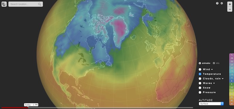
Commuters in the Denver metro area will experience quite a shock on Thursday morning. Following temperatures that rosenear 80 on Tuesdayand likely will soarabove 80 on Wednesdayafternoon, Denver will then be blasted with snow and frigid temperatures that plungeinto the teens by Wednesday night into Thursday.

Early Wednesday morning, the bulk of the snow was falling over portions of Montana,AccuWeather radar indicated. However, snow and slippery travel was also being reported in portions of Washington state, including around Spokane where new daily snowfall record for Oct. 8 was set. Spokane International Airportrecorded 3.3 inches of snowTuesday, shattering the previous record for the day, which was a trace set in 1981.

More than 31,000 power outages were reported in the Spokane area early Wednesday morning,according to Avista, the energy company that provides power to much of the region. There were also numerous reports of tree limbs breaking from the weight of the snow.
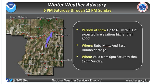
Aslew of winter storm warnings and watches and freeze warnings were in effect across parts of seven states as the storm ramped up Wednesday.

Arctic air is charging southward at the same time a storm moves eastward from the Pacific Ocean over the northern Rockies and Plains.

The arrival of the Arctic air and the strengthening storm will cause weather conditions to change rapidly, whether in the mountains, over the passes or on the Plains.

As temperatures plunge to the 30s, 20s and teens, any rain that falls during the onset of the storm will change to snow from north to south and from higher elevations to lower elevations in the region.

Motorists will be at risk from getting stuck as road conditions quickly transition from wet to slushy and snow-covered.

Travel along portions of Interstate 15, I-25, I-29, I-70, I-80, I-90 and I-94 will be difficult and dangerous. It is possible that travel on portions of some of these major highways is shut down for a time into late week. (Article continues with maps.)
~In the article above, I want to point out this map that shows the weather pattern of the storm:

Aslew of winter storm warnings and watches and freeze warningswere in effect across parts of seven states as the storm ramped up Wednesday.


Arctic air is charging southward at the same time a storm moves eastward from the Pacific Ocean over the northern Rockies and Plains.

The arrival of the Arctic air and the strengthening storm will cause weather conditions to change rapidly, whether in the mountains, over the passes or on the Plains.

~ ...
and compare that map - to the one describing the timing of a second meteor shower over the same locations:

Wednesday night to bring 2nd meteor shower in 2 nights
https://www.accuweather.com/en/weat...sky-as-2-meteor-showers-peak-next-week/595355

Updated Wed. Oct. 9, 2019 8:16 AM -
Following the Draconid meteor shower on Tuesday night, another meteor shower will peak at midweek. The Southern Taurids will be the second meteor shower to peak in as many nights.

Similar to the Draconids, the Southern Taurids are a minor shower with fewer than 10 meteors per hour, but don’t let the slim numbers discourage you.

“The Taurids are rich in fireballs,” theAmerican Meteor Society said on their website.

Fireballs are meteors that appear incredibly bright as they streak through the sky. They can be so bright that they can cast shadows on the ground for several seconds.


主要是晴朗的天空将允许不间断viewing conditions for much of the U.S. on Wednesday night with the exception of widespread clouds over the northern Plains, as well as along the coastal Northeast.

Folks that miss these meteor showers do not have to wait long for another opportunity to spot some shooting stars. TheOrionid meteor shower peaks later this monthon the night of Oct. 21 into Oct. 22 and usually brings around 20 meteors per hour.

Onlookers that see meteors streaking from the northwestern sky will know that they are part of the Draconids. Meanwhile, those that can be traced back to the eastern sky will be part of the Southern Taurids.

Beorn

Beorn

Jedi Council Member
FOTCM Member
I found this video really helpful in explaining how energy from the sun is transferred through the atmosphere to the Earth and then reflected back out to space.


Almost all of the radiation that CO2 can trap is being absorbed by the atmosphere, meaning an increase in CO2 will have very little affect on temperature. This graph was the most helpful for me. It shows the spectrum of radiation that CO2 and other gases can absorb. The vertical line goes through the center point for CO2. At that point 100% of thermal radiation is already being absorbed, mostly by water vapor.Radiation Transmitted by the Atmosphere.jpg
T

thorbiorn

The Living Force
FOTCM Member
Toeing the line, but interesting research that provides a concrete example of what to expect when there is more snow: FromAn ecosystem-wide reproductive failure with more snow in the Arcticthe abstract reads:
2018: Arctic researchers have just witnessed another extreme summer—but in a new sense of the word. Although public interest has long been focused on general warming trends and trends towards a lower sea ice cover in the Arctic Ocean, this summer saw the realization of another predicted trend: that of increasing precipitation during the winter months and of increased year-to-year variability.In a well-studied ecosystem in Northeast Greenland, this resulted in the most complete reproductive failure encountered in the terrestrial ecosystem during more than two decades of monitoring: only a few animals and plants were able to reproducebecause of abundant and late melting snow.These observations, we suggest,should open our eyes to potentially drastic consequences of predicted changes in both the mean and the variability of arctic climate.
On DMI.dk where I found the link to the article in English, there are somecomments for the public:
Multiple records in all directions.

Martin Olesen points out the most striking aspect of the investigation into the massive snowfall.:

”The result is in line with the expected effects of climate change. We have anticipated that one of the consequences of global warming is more extreme weather, with greater fluctuations and thus more ’record-weather’. Andthe records are expected to run out in every direction– in the fields of heat, drought and storms, butalso in the cold and high snow levels.

We assume that the snowfall of this size in the Arctic will happen again, but it is too early to say how often it will happen.”

At some point, however, it is to be expected that the fundamentally rising global temperature will ’overtake’ the records related to cold.
From the above it is now more easy to move to the position that not only was the part of the new finding with the predictions of colder weather and more snow right, the former expectation that the "fundamentally rising global temperature will ’overtake’ the records related to cold."was fundamentally wrong.

On thepage of the article at DMI.dkthey present a diagramme that shows the deviation from the average snow fall since 1981, what is actually noticeable is that two years 1987 and 2018 are more off on the high snow season side, than any years with poor snow seasons. There is to little data to conclude anything, but that might be a pattern one could look into.
1571740034917.png
Top Bottom